|
|
|
|

|
|
Map including all of Israel portrayed as “Palestine” in PA daily cartoon
|
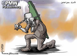
This cartoon shows a Palestinian prisoner carrying the weight of “Palestine” on his shoulders. The map includes both Israeli and Palestinian territories.
Text: “The prisoners – The pack camels (i.e., camels used for carrying loads)”
|
|
Al-Hayat Al-Jadida
|
|
Dec. 20, 2012
|
|
|
|
|
|
|
|
|

|
|
1- PA schoolbooks and schools use maps erasing Israel
|
|
|

|
|
|
|

|
|
|

|
|
2- PA leaders with maps erasing all of Israel
|
|
|

|
|
|
|

|
|
|

|
|
3- Flags designate all of Israel as "Palestine"
|
|
|

|
|
|
|

|
|
|

|
|
4- PA government uses maps erasing all of Israel
|
|
|

|
|
|
|

|
|
|

|
|
5- Terror organization logos erasing all of Israel
|
|
|

|
|
|
|

|
|
|

|
|
6- PA-controlled media uses maps erasing Israel
|
|
|

|
|
|
|

|
|
|

|
|
7- PA cartoons use maps erasing all of Israel
|
|
|

|
|
|
|

|
|
|

|
|
8- Public and private use of maps erasing Israel
|
|
|

|
|
|
|

|
|
|
|
|
|
|