Map at kids' exhibit in Lebanon: "The borders of Palestine"
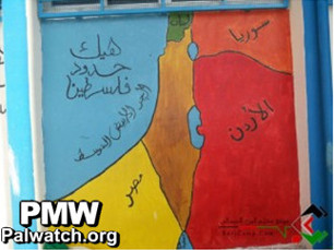
Title of map: "The borders of Palestine"
The map shows the Mediterranean Sea, Lebanon, Syria, Jordan and Egypt as the borders of "Palestine."
This map was part of an exhibit called "This is Palestine." The maps in the exhibit were painted by Palestinian children from Lebanon. The exhibit was funded by the NGO Norwegian People's Aid, which is funded by the Norwegian Ministry of Foreign Affairs and the Canadian International Development Agency.