PA daily published rare map that clearly differentiates between Israel and PA areas
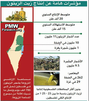
Image of map and data published in the weekly economic supplement of the PA daily The image shows olive oil and olives at the top left, the PA map of "Palestine" that presents all of Israel as "Palestine" together with the PA areas on the left, olive tree branches and olive oil being poured on the right, and statistics about Palestinian olive oil production.
Text on top of image: "The main statistics of olive oil production"
Text on left side under the map: "All of the lands on which olive trees are planted in Palestine reaches 750,000 dunams [1 dunam = 1,000 sq. meters], and they constitute 54% of all of the cultivated areas."
Text on right side:
"Average annual production: 20,000 tons
Average annual consumption: 15,000 tons
Number of olive trees: 11 million
10 million in the West Bank
One million in the Gaza Strip
Trees bearing fruit: 9.5 million
Olive presses: 262 in the West Bank
29 in Gaza
Jenin is the Palestinian district that produces the most olive oil, with 23-25% of all of the Palestinian production"