Fatah Facebook post features map of “Palestine” replacing Israel, “the territory that was occupied in 1948”
Text and image posted on the official Fatah Facebook page
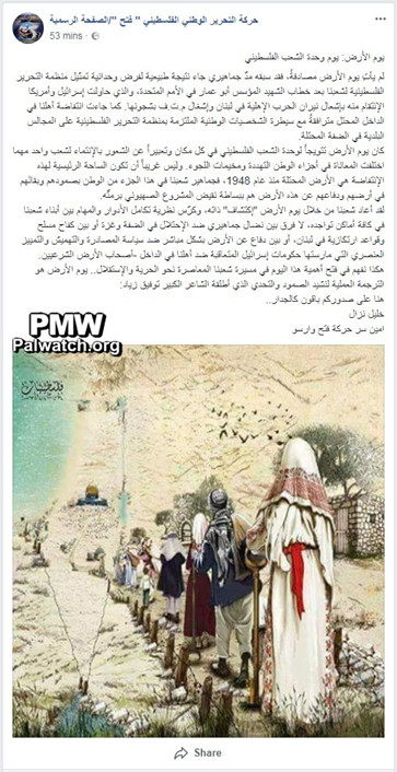
The image shows people in in keffiyehs (Arab headdresses) walking towards "Palestine," depicted by the PA map of “Palestine” that presents all of Israel as “Palestine” together with the PA areas with the Dome of the Rock appearing at the location of Jerusalem. To the left of the map is written "Palestine."
Posted text: "Land Day is the height of the Palestinian people's unity everywhere and an expression of the feelings of belonging to one people, no matter how different the suffering in the different parts of the homeland and in the refugee camps. It is not odd that the main arena of this intifada is the territory that was occupied in 1948 (i.e., Israel), as the masses of our people in this part of the homeland – with their resolve, their remaining on their land, and their defense of this land – are simply the opposite of the Zionist project as a whole…
Khalil Nazzal
Fatah Movement Secretary in Warsaw"
Land Day – annual commemoration of the general strike and demonstrations organized by Israeli Arab residents of the Galilee on March 30, 1976 to protest the Israeli government's decision to expropriate land in the Galilee for security and building purposes, which it later implemented. During the protests, demonstrators burnt tires, blocked roads, and threw rocks and firebombs. Six demonstrators were shot and killed by the Israeli army and police. Israeli Arabs and Palestinians consider Land Day a national day.